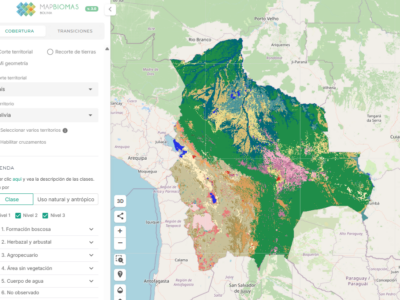
The MapBiomas Bolivia Project is a product that covers the entire Bolivian territory and has been the result of the learning from four collections of annual maps of land cover and land use developed within the framework of the MapBiomas Amazonia project, where the Bolivian Amazon basin has been mapped. This allowed the development of methodological and technological tools that have been adapted to complete the mapping of the entire national territory.

To date, the achieved result is the following collection:

Collection 1.0 - Maps of Bolivia, for the period 1985-2021: 14 classes were mapped using the Random Forest classifier, and 8 cross-cutting layers were developed.

ATTENTION:

The maps from the MapBiomas Bolivia Collections are an evolving product. When selecting data, make sure you are always using the latest available version.
We recommend using the MapBiomas Bolivia maps up to a scale of 1:100,000. Although it is possible to view them at larger scales (1:50,000), we do not recommend using them at this scale.

PRODUCTS AVAILABLE FOR ALL THE PUBLIC

Land use and land cover maps: maps in raster format (30x30 m pixel). The legend of these maps, as well as the covered period, evolve from one collection to the next.

Mosaics of cloud-free satellite images: representative for each year of the historical series, with a maximum spatial resolution of 30 meters. The mosaics are formed by the composition of cloud-free pixels in each set of images for a certain time period. The periods of the year in which the images are selected vary according to the region of each country. The mosaics contain 141 layers of information formed by the original bands of Landsat images as well as indices, spectral bands and fractions derived from them. The mosaics can be accessed directly in Google Earth Engine for processing or download.

Public Web Platform: with infographics, factsheets, maps and statistics of the MapBiomas Bolivia Collection 1.0.

PRODUCTS AVAILABLE FOR SPECIALISTS OR DEVELOPERS

Collection of image processing and classification scripts
Methodological notes (in ATBD format) explaining the entire work method, including the specificities of each country and cross-cutting mapping.